3 Settlement Map Generators Compared
A settlement map generator produces a top-down map of a hamlet, village, town, or city, laying out streets, buildings, walls, rivers, and notable districts procedurally rather than requiring the GM to draw one by hand. The fastest use case is unprepared session play: a party turns off the main road, and the GM needs a believable village in the next thirty seconds. The slower use case is worldbuilding: generating dozens of candidate settlements until one feels right, then committing to it.
TTRPG map tools split along three axes: generator vs. editor (an editor with generation features is an editor first), scale (world, region, settlement, tactical), and sub-type within each scale (caves vs. dungeons vs. battle scenes vs. buildings at the tactical scale). On the generator side, tools tend to specialize per sub-type. On the editor side, those sub-types collapse: dungeons, caves, battle scenes, and building interiors are all built in the same generalized tactical-map editor. This article covers settlement-scale generators; see also Dungeon Map Generators Compared for the tactical scale, and Dungeon & Battle Map Editors Compared for the editor counterpart.
When comparing settlement generators, the main differentiators are output style (cartographic vs. painted vs. schematic), configurability (named cultures, walls, rivers, town sizes), and named output (district names, town names, population counts).
Donjon
Voronoi-Cell Towns with Cultural Knobs
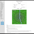
*Donjon's Random Town Generator produces a named settlement drawn as a Voronoi-cell street grid laid over a colour-coded environment background. It exposes more configuration than most peers in one screen: environment (grassland, forest, desert, etc.), topography (inland, coastal), an optional river, a walls toggle, a town-size dropdown with named tiers from hamlet up to large city, and race and culture selectors that influence the generated name and labels.
The visual output is schematic rather than illustrated, useful as a reference for the GM rather than a handout for players. The strength is speed: every option fits on one screen, regeneration is instant, and the cultural knobs help when a campaign uses non-default human-medieval naming.
Watabou
Medieval Fantasy City Generator
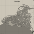
*The Medieval Fantasy City Generator produces walled cities rendered in a parchment-and-ink cartographic style. Output includes named districts (slums, markets, harbour quarters), a castle or citadel, temples, gates, and a labelled street layout, complete with scale bar and compass. Configuration covers city size, coastline, rivers, walls, shanty towns, and several visual styles, with export options that include image and SVG.
Seeds and option settings are encoded in the URL, so a specific generated city can be shared or bookmarked. The output quality is high enough to use directly as a player-facing handout. The trade-off versus Donjon is fewer cultural knobs and a stronger commitment to a single medieval-European aesthetic.
Village Generator
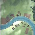
*Watabou's Village Generator targets a smaller scale than the city generator and renders in a fully painted top-down style with fields, forests, lakes, dirt paths, and docks rather than ink lines. Every village is labelled with a generated name and population count, and tag-based customization controls features like rivers, central squares, and how isolated the settlement feels.
Stylistically it is the most painted-looking option in this comparison, closer to a hand-illustrated regional vignette than a top-down city plan. That makes it well suited as a player handout for a small settlement encounter rather than a reference plan for a city the party will explore deeply.
Kassoon
Hamlet, Village, and Town Maps Across Three Sizes
D&D 5e
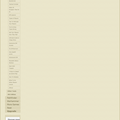
Kassoon offers three discrete settlement generators rather than a single configurable one, with each tool fixed to a particular scale. The Medieval Town Map Generator produces a 2D town with buildings, roads, districts, and labelled landmarks; the Medieval Village Map Generator scales down to a smaller layout; and the Hamlet Map Generator targets the smallest tier with buildings, paths, and a few points of interest. Each generates a fresh randomized layout per load.
The split-by-size approach is the structural difference from Donjon and Watabou MFCG. Where those tools expose a "size" dropdown inside one generator, Kassoon commits to three separate pages, each tuned to its tier. The output is D&D 5e-flavoured and aimed at GMs who want a quick visual reference rather than a print-ready handout.
Choosing a Generator
Donjon's Random Town Generator wins on configuration breadth in a single screen (environments, cultures, races, walls, rivers), with output suited to GM reference rather than to player handouts. When you need print-ready cartography of a walled city, Watabou's Medieval Fantasy City Generator produces the highest-quality handouts in this set, with named districts and a deeply configurable URL-encoded seed. Watabou's Village Generator stands alone in style for small-scale handouts: its painted look reads as illustration rather than draft. Kassoon's three-tool split fits a different workflow, where you pick a scale tier up front and accept the defaults from there, with each of hamlet, village, and town getting its own dedicated generator instead of crowding a single options panel.